Book a Hotel & Get Directions with TomTom’s New Nav Device
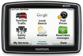
TomTom just launched an innovative GPS navigation device. Now, with TomTom’s new GO LIVE 153 5M GPS device, users will be able to read reviews, or find and book a hotel, as well as check local gas prices and weather forecasts through TomTom LIVE’s other apps and services.
GPS navigation devices have typically been limited in their ability to tell you where you should go, unable to provide a way to choose between the three local motels and the five Mom-and-Pop restaurants in town. Services like Yelp and TripAdvisor solve this problem in useful ways, and TomTom is taking advantage: On Monday, according to PC Mag, the company announced the TomTom GO LIVE 153 5M, which combines the navigation power of TomTom with the reviews and information of related apps.
The GO LIVE 1535 M gives away its features in its title. The LIVE portion references the TomTom LIVE services, which connect TomTom devices to the Web and allow them, in the case of the 1535M, to access sites like Yelp, Trip Advisor, Expedia and Twitter. Right from their GPS, users will be able to read reviews, or find and book a hotel, as well as check local gas prices and weather forecasts through TomTom LIVE’s other apps and services.